Understanding Weather Fronts: Key Insights for Boaters and Sailors
June 10th, 2024 by team
by B.J. Porter (Contributing Editor)
If you watch a weather report, on a national level, you’ll often see the meteorologist standing in front of the national map, waving their hands at the various red and blue curves with spikes and lumps on them. They’ll talk about “cold fronts” and “warm fronts,” and show them moving across the country with descriptions about what each region can expect.
Last month we talked about barometric pressure, and low and high pressure systems and air masses. We discussed how they moved, changing barometric pressures, and how that all ties to changes in the weather. This month, we’re talking more about those air masses and we’ll get into a little more detail on how they move and interact.
But first, what is a front and how does it concern you as a boater?
What is a front?
In weather terms, a front is the edge of a moving mass of air where it contacts another mass. On a global and regional scale, large air masses are characterized by temperature and air pressure. The air masses will also have different motion and moisture content. It’s usually the leading edge of the moving system and how it interacts with other systems that’s of interest.
Last month we learned that high pressure systems have colder, drier air and low pressure masses were warmer and wetter. It’s these fundamental differences in the air masses that lead to some…interesting…interactions and reactions when the different systems meet at a front.
When we spoke about the expected weather in the pressure systems, that referred to the weather in the middle of the system. So while you can expect clearing conditions and cooler weather with a high pressure system, the associated front may be quite turbulent when it moves through.
Types of fronts
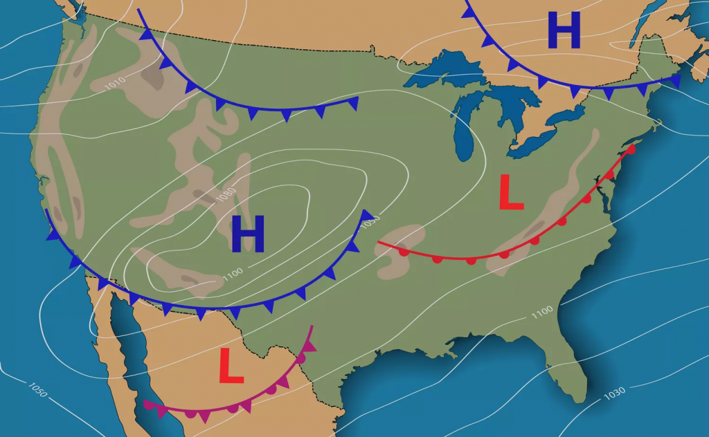
There are two primary types of fronts you’ll see on a synoptic weather map: warm fronts and cold fronts. Different interactions between warm and cold fronts can create stationary fronts and occluded fronts.
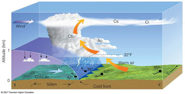
Cold Fronts
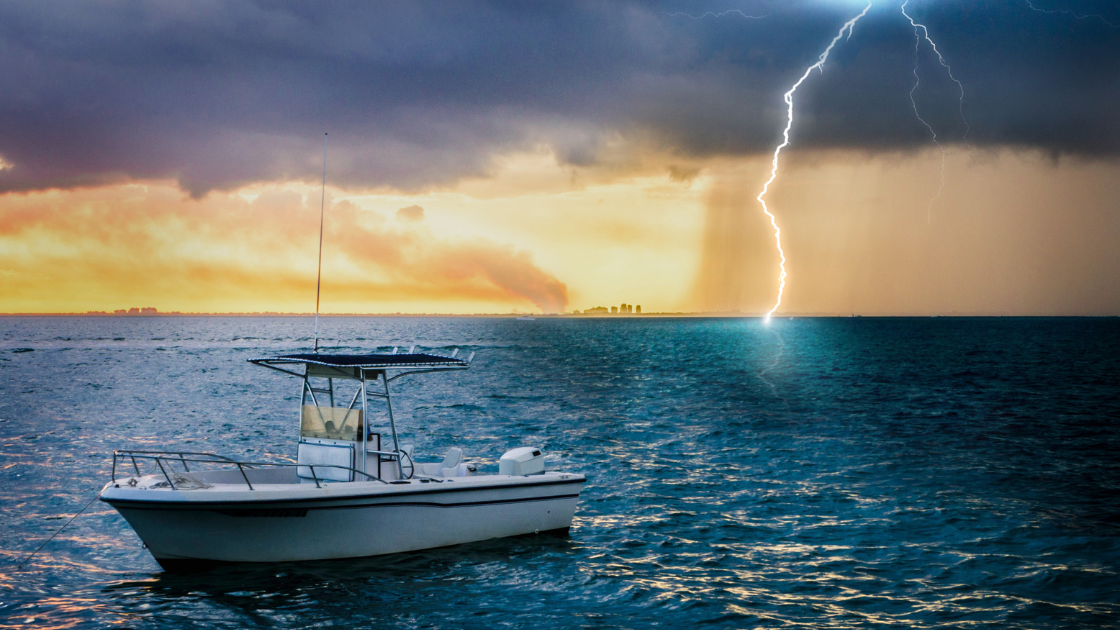
A cold front is associated with a mass of cooler, higher pressure air contacting a slower moving mass of warm air. The fast moving cold air pushes the warm air mass out of the way. The cold air pushes the warm air up and over it, or forward of the cold front.
Warm, wet air pushed up from the earth will cool, and this releases some of the water held in the air. The shoveling of the warm air out of the way can lead to rain, towering cloud formations, and windy thunderstorms. The exact weather in the front passing varies with the stability of the front and the temperature and moisture differences between the colliding air masses.
In the northern hemisphere, most cold fronts move from west to east, most typically from the northwest to southeast. South of the equator, cold fronts move from southwest to northeast.
As a cold front approaches, local temperatures may increases the barometer drops. During the front, rain and stormy weather may happen, followed by cooler temperatures and stabilized higher atmospheric pressure.
On a weather map, a cold front is a blue curve with spiked triangles pointing in the direction the front is moving.

Warm Fronts
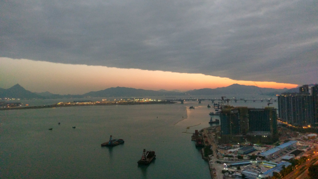
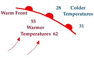
Warm fronts move more slowly than cold fronts. Warm air is less dense than cold air, so the warmer air mass rides up over the cold. Moving in, they often start with high, wispy clouds and may turn to rain in a day or two. Temperatures will warm as the air mass settles. Since they move slowly, the weather changes are slower, longer, and usually less violent than passing cold fronts.
Warm fronts aren’t often as sharply delineated as cold fronts, and move about half the speed. Typical movement is from southwest to northeast, though dense cold air masses can distort path and shape of warm fronts.
On a weather map, a red line with semicircles on the side of motion shows warm fronts.
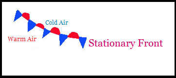
Stationary Fronts
Cold fronts bulldoze warm air masses out of the way, and warm fronts flow over cold air masses or fill in behind them as the cold air retreats. But what happens when an air mass doesn’t move and the other front can’t get around it? You get a stationary front.
A stationary front is an air mass traffic jam. Neither mass can move around the other, and the frontal conditions may last for days. This is typically low cloud cover, long periods of rain, and very light winds parallel to the frontal zone.
On a weather map, a stationary front is a line of alternating red half-circles and blue spikes.
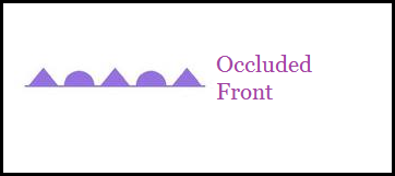
Occluded Fronts
When a cold front hits a warm front and pushes the warm air into a large layer over the cold front, the new front becomes occluded. In the northern hemisphere, as the frontal systems fold together you’ll get three fronts spiraling from a center – a cold front to the south, a warm front to the east, and the occluded front extending north.
The formation of an occluded front can cause intense wind with thunderstorms and rain, which dissipate over several days as the air systems mix and the lose the sharp differences in pressure and temperature.
An occluded front is a purple line with alternating triangles and semi-circles pointing toward the front’s movement. This is almost always part of a three armed front system as described above.
Trough
Another term you may here is trough (pronounced “trof”). It isn’t really a front, though it can be associated with frontal systems. A trough is essentially an elongated valley of low pressure with lying between or near weather fronts. A trough in the upper atmosphere may only cause a minor disturbance in surface weather, but a surface level trough can give several days of sharp winds, cloud cover, thunderstorms, and rain depending on how fast it’s moving.
There’s no standard symbol for a trough. There might be a black dashed line on U.S. NOAA maps, a bold line in the U.K., and so on. Look for the word “trof” and elongated low pressure isobars.
What to do with fronts?
So when you look at a weather map, how do you make sense of all these fronts and lines? In a future post, we’ll focus on how to read synoptic and other types of weather maps in more detail. For now, you need to know what types of fronts are coming, and when they might pass through. You can check weather prediction maps to see how meteorologists expect today’s fronts and air masses to move.
As we’ve read, most fronts are closely associated with disturbed weather until the front has passed and the main mass of the pressure system has moved into the region. Local marine forecasts and weather maps will show front movement and give predictions for when they might arrive and expected conditions.
Cold fronts, troughs, and occluded fronts have the most unpleasant weather, and it’s best to stay put and not venture out into an arriving frontal system. If it comes through in the middle of your vacation, check your anchor or dock lines, and get out a deck of cards or a good book and wait it out. For a weekend trip during a front, hopefully you saw the front coming and stayed home. If you didn’t, plan to stay for another day or two if you can until the front settles. There’s no sense knowingly heading out into the big wind and waves.
Warm fronts are mostly wet and miserable to travel through, as are stationary fronts. While they aren’t without danger, if you’ve got a decent set of foulies and working radar, you can usually make your way home. It might not be very pleasant, but you’re unlikely to hit strong winds and dangerous waves.
Look ahead, make a plan
There’s no excuse for any boater to head out without checking the weather. At a minimum, you should always look the morning you’re leaving. But for longer trips with overnights and to places you can’t come back from in a few hours, watch the weather for days before departure.
As a boater, it’s never a bad idea to watch weather patterns every day, whether or not you’re planning a trip. There are broader patterns you can learn about your regional weather, and the more you know, the better you can plan.
Fronts and weather systems don’t always have to keep you home, and with some preparation and planning, you can work around them safely. It may mean leaving a day early or later, or spending an extra day somewhere you didn’t plan. But it’s always better to be careful and never head out when you’re expecting a sudden shift to bad weather.
Resources
For general U.S. weather, the National Weather Service has many excellent products where you can look at the fronts, pressure systems, and other ideas we’ve discussed. Poke around all you want, it’s all free.
https://www.weather.gov/forecastmaps/
For marine focused weather – the type which concerns us the most – the Radiofax charts are a great place to start with synoptic weather maps and other useful links.
https://www.weather.gov/marine/radiofax_charts
Here’s a preview of next month’s topic in How to read Surface Weather Maps.
The U.K. Met Office has excellent resources for U.K. and Europe
https://www.metoffice.gov.uk/weather/maps-and-charts/surface-pressure
For other regions and language, check the government weather agencies.
Comments are closed.
