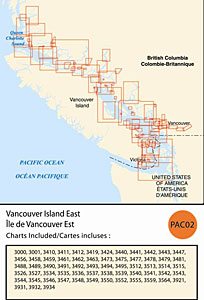
CHS: RM-PAC02 Vancouver Island East
Coverage includes but is not limited to:
- Covers Victoria to Prince Rupert including Vancouver, Sunshine Coast, Desolation Sound and navigable harbours.
- Contains Raster Navigation Charts (RNC) in BSB V3 format of the following paper charts:
- 3000, 3001, 3410, 3411, 3412, 3419, 3424, 3440, 3441, 3442, 3443, 3447, 3456, 3458, 3459, 3461, 3462, 3463, 3473, 3475, 3477, 3478, 3479, 3481, 3488, 3489, 3490, 3491, 3492, 3493, 3494, 3495, 3512, 3513, 3514, 3515, 3526, 3527, 3534, 3535, 3536, 3537, 3538, 3539, 3540, 3541, 3542, 3543, 3544, 3545, 3546, 3547, 3548, 3549, 3550, 3552, 3555, 3559, 3564, 3921, 3931, 3932, and 3934.