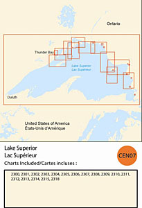
CHS: RM-CEN07 Lake Superior
Coverage includes but is not limited to:
- Covers the Canadian side of Lake Superior from Coppermine to west of Thunder Bay including navigable harbours.
- Contains Raster Navigation Charts (RNC) in BSB v3.0 format of the following paper charts:
- 2300, 2301, 2302, 2303, 2304, 2305, 2306, 2307, 2308, 2309, 2310, 2311, 2312,, 2313, 2314, 2315, and 2318.