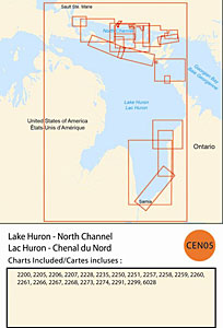
CHS: RM-CEN05 Lake Huron – North Channel
Coverage includes but is not limited to:
- Covers Canadian side of Lake Huron from Sarnia to Sault Ste. Marie including all of the North Channel and navigable harbours.
- Contains Raster Navigation Charts (RNC) in BSB v3.0 format of the following paper charts:
- 2200, 2205, 2206, 2207, 2228, 2235, 2250, 2251, 2257, 2258, 2259, 2260, 2261, 2266, 2267, 2273, 2274, 2291, 2299, and 6028.