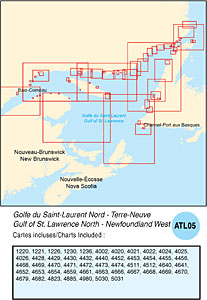
CHS: RM-ATL05 Gulf of St. Lawrence North – Newfoundland West
Coverage includes but is not limited to:
- Covers Sept- Iles to Strait of Belle Isle to Channel Port Aux Basque including Anticosti Island, Bay of Islands and navigable harbours.
- Contains Raster Navigation Charts (RNC) in BSB V3 format of the following paper charts:
- 1220, 1221, 1226, 1230, 1236, 4002, 4020, 4021, 4022, 4024, 4025, 4026, 4428, 4429, 4430, 4432, 4440, 4452, 4453, 4454, 4455, 4456, 4468, 4469, 4470, 4471, 4472, 4473, 4474, 4511, 4512, 4640, 4641, 4652, 4653, 4654, 4659, 4661, 4663, 4666, 4667, 4668, 4669, 4670, 4679, 4682, 4823, 4885, 4980, 5030, and 5031.