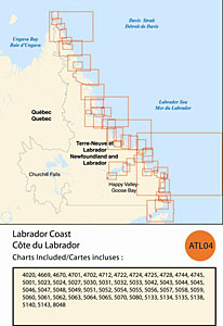
CHS: RM-ATL04 Labrador Coast
Coverage includes but is not limited to:
- Covers St. Anthony to Cape Chidley including Goose Bay, Nain and navigable harbours.
- Contains Raster Navigation Charts (RNC) in BSB V3 format of the following paper charts:
- 4020, 4669, 4670, 4701, 4702, 4712, 4722, 4724, 4725, 4728, 4744, 4745, 5001, 5023, 5024, 5027, 5030, 5031, 5032, 5033, 5042, 5043, 5044, 5045, 5046, 5047, 5048, 5049, 5051, 5052, 5054, 5055, 5056, 5057, 5058, 5059, 5060, 5061, 5062, 5063, 5064, 5065, 5070, 5080, 5133, 5134, 5135, 5138, 5140, 5143, and 8048.