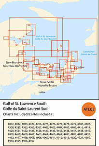
CHS: RM-ATL02 Gulf of St. Lawrence South
Coverage includes but is not limited to:
- Covers from Miramichi to Gaspe inluding Iles de La Madelene, Cape Breton, Bras D’Or Lakes Prince Edward Island, Northumberland Strait and navigable harbours.
- Contains Raster Navigation Charts (RNC) in BSB V3 format of the following paper charts:
- 4002, 4022, 4023, 4024, 4266, 4275, 4276, 4277, 4278, 4279, 4302, 4307, 4308, 4335, 4363, 4365, 4367, 4402, 4403, 4404, 4405, 4406, 4416, 4419, 4420, 4421, 4422, 4425, 4426, 4437, 4443, 4445, 4446, 4447, 4448, 4449, 4450, 4459, 4460, 4462, 4463, 4464, 4466, 4467, 4483, 4485, 4486, 4491, 4492, 4497, 4498, 4905, 4906, 4909, 4911, 4912, 4913, 4920, 4921, 4950, 4954, 4955, 4956, and 4957.