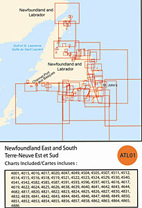
CHS: RM-ATL01 Newfoundland East and South
Coverage includes but is not limited to:
- Covers from Channel Port aux Basques to the Avalon Peninsula to Cape Bauld including Placentia Bay, St. John’s, Notre Dame Bay and navigable harbours.
- Contains Raster Navigation Charts (RNC) in BSB V3 format of the following paper charts:
- 4001, 4015, 4016, 4017, 4020, 4047, 4049, 4504, 4505, 4507, 4511, 4512, 4514, 4515, 4516, 4518, 4519, 4521, 4522, 4523, 4524, 4529, 4530, 4540, 4541, 4542, 4582, 4585, 4587, 4591, 4593, 4596, 4597, 4615, 4616, 4617, 4619, 4622, 4624, 4625, 4626, 4638, 4639, 4640, 4641, 4642, 4643, 4644, 4682, 4817, 4820, 4821, 4822, 4823, 4824, 4825, 4826, 4827, 4830, 4831, 4832, 4839, 4841, 4842, 4843, 4844, 4845, 4846, 4847, 4848, 4849, 4850, 4851, 4852, 4853, 4854, 4855, 4856, 4857, 4858, 4862, 4863, 4864, 4865, and 4886.