Instruments View
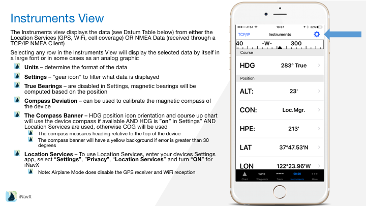
The Instruments view displays the data (see Datum Table below) from either the Location Services (GPS, WiFi, cell coverage) OR NMEA Data (received through a TCP/IP NMEA Client)
Selecting any row in the Instruments View will display the selected data by itself in a large font or in some cases as an analog graphic
– Units – determine the format of the data
– Settings – “gear icon” to filter what data is displayed
– True Bearings – are disabled in Settings, magnetic bearings will be computed based on the position
– Compass Deviation – can be used to calibrate the magnetic compass of the device
– The Compass Banner – HDG position icon orientation and course up chart will use the device compass if available AND HDG is ”on” in Settings” AND Location Services are used, otherwise COG will be used
– The compass measures heading relative to the top of the device
– The compass banner will have a yellow background if error is greater than 30 degrees
– Location Services – To use Location Services, enter your devices Settings app, select “Settings”, ”Privacy”, “Location Services” and turn “ON” for iNavX
– Note: Airplane Mode does disable the GPS receiver and WiFi reception
Configuring Instruments
| Datum | Description | Location Services | NMEA 0183 | NMEA 2000 | Analog Graphic or Extended Data Available when “Show Digital is Disabled |
| AAD | Anchor Alarm Drift | X | X | X | |
| ALT | Altimeter | X | X | X | |
| AWP | All Waypoints | X | X | X | X |
| ALV | Alternator Volts | X | |||
| AWA | Apparent Wind Angle | X | X | X | |
| AWS | Apprarent Wind Speed | X | X | X | |
| BAT | Battery Wind Vane | X | |||
| BPR | Barometric Pressure | X | X | ||
| BSP | Boat Speed | X | X | X | |
| BTV | Battery Volts | X | |||
| BTW | Bearing To Waypoint | X | X | X | |
| COG | Course Over Ground | X | X | X | X |
| CON | Connection | X | X | X | |
| DBT | Depth Below Transducer | X | X | X | |
| DPT | Depth | X | X | ||
| DTR | Distance Remaining In Route | X | X | X | X |
| DTW | Distance To Waypoint | X | X | X | |
| ETA | Estimated Time Of Arrival | X | X | X | |
| ETP | Engine Temperature | X | |||
| FIX | Position Type | X | X | ||
| FLC | Fluid Capacity | X | |||
| FLL | Fluid Level | X | |||
| FLR | Fuel Rate | X | |||
| GSV | Satellites In View | X | X | X | |
| HDG | Heading | X | X | X | |
| HDM | Heading Magnetic | X | X | ||
| HDT | Heading True | X | X | X | |
| HPE | Horizontal Position Error | X | X | X |
| LAT | Latitude | X | X | X | |
| LON | Longitude | X | X | X | |
| MWD | Magnetic Wind Direction | X | |||
| OIL | Oil Temperature and Pressure | X | |||
| ROT | Rate Of Turn | X | X | ||
| RPM | Revolutions Per Minute | X | |||
| RTN | Route Name | X | X | X | X |
| SBS | Switch Bank Status | X | |||
| SOG | Speed Over Ground | X | X | X | X |
| SYT | System Time | X | X | ||
| TCT | Target Count | X | X | X | |
| TMP | Water Temperature | X | X | ||
| TMR | Time Remaining | X | X | X | X |
| TOA | Time Of Arrival | X | X | X | |
| TPO | Air Temperature | X | |||
| TRG | Transmission Gear | X | |||
| TRT | Transmission Temperature and Pressure | X | |||
| TTG | Time To Go | X | X | X | |
| TWA | True Wind Angle | X | X | X | |
| TWD | True Wind Direction | X | |||
| TWS | True Wind Speed | X | X | X | |
| TXT | Text | X | |||
| UTC | Universal Time Coordinate | X | X | X | |
| VAR | Magnetic Variation | X | X | X | |
| VMG | Velocity Made Good | X | X | X | |
| VPE | Vertical Position Accuracy | X | X | X | |
| WPN | Waypoint Name | X | X | X | |
| XTE | Cross Track Error | X | X | X | X |
